
Marloes and St Brides
QUICK LINKS
WHAT’S NEW
PENINSULA PAPERS
The closing date for the
September edition is
Friday 21st August
Marloes and St. Brides in Pembrokeshire
Welcome to our community website
The communities of Marloes and St Brides (population 323 in 2001) are situated west of Haverfordwest on a peninsula on the southern shore of St Brides Bay, within the Pembrokeshire Coast National Park.
Marloes & St Brides are surrounded to the north, west and south by sea, with 10 km of beautiful cliff scenery and beaches such as St Brides Haven and Marloes Sands. The parish also includes the island of Skomer, famous for its large populations of seabirds, including Puffins and Manx Shearwaters. Skomer is accessed by boat from Martin's Haven at the tip of the peninsula. Also included are the small islands of Grassholm (home to a large population of Gannets) and Gateholm. (See Maps)
Marloes itself is a small village perched in the high land in the centre of the Marloes peninsula. It is usually pronounced “Mar-lows” but locals often say "Marlas". The name appears to derive from Old Welsh mail = "bare" and ros = "moor" or "promontory", identical to Melrose in Scotland. The residents of Marloes have traditionally been known as “GULLS” - based on the the tradition of harvesting gulls eggs from Skomer.
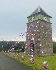
In the centre of Marloes is the well known landmark - the Clock Tower. This was built in 1904 by members of the Pembrokeshire Liberal Association as a memorial to the 4th Baron Kensington. For more information click HERE.
An interesting poem about Marloes written in 1927 can be read here “Marloes Village”.
St Brides comprises a number of scattered farms and dwellings, with a delightful old church situated behind St Brides Haven, a sandy cove on the north coast of the peninsula. The picturesque St Brides Castle (a Holiday Property Bond property) overlooks the haven.
Details of local services such as accommodation, restaurants, bus services and the shop can be found by following links to on the left of the page or from the menus above.
For more on the traditions and culture of the area have a look at the TRADITIONS AND CULTURE page. For more on the history of the area look at the HISTORY page.


If you find the text is too small to read comfortably then try pressing CTRL and + at the same time - it should make everything bigger. To make it smaller again use CTRL and -


MARLOES PUBLIC ACCESS DEFIBRILLATORS
Marloes Centre: on the toilet block wall next to the public telephone
Marloes Sands: On the toilet block on the old YHA building at Runwayskiln (near the Marloes Sands car park)
Dale: The Boathouse Cafe
Dale Castle: On the castle wall near the gate leading to West Dale
St Ann’s Head: At the Old Lighthouse
Martins Haven: On the stone building containing the toilets
Deer Park: NCI Coastwatch Hut
St Brides Haven: On the toilet block
Pearson Farm, St Brides:
At the entrance
There are also defibrillators at St Ishmaels - at the Brook Inn, Children’s Play Park, Monkhaven Church, Burgage Green by the post box, and Sandy Hill Chapel.


The communities of Marloes and St Brides (population 323 in 2001) are situated west of Haverfordwest on a peninsula on the southern shore of St Brides Bay, within the Pembrokeshire Coast National Park.
Marloes & St Brides are surrounded to the north, west and south by sea, with 10 km of beautiful cliff scenery and beaches such as St Brides Haven and Marloes Sands. The parish also includes the island of Skomer, famous for it large populations of seabirds, including Puffins and Manx Shearwaters. Skomer is accessed by boat from Martin's Haven at the tip of the peninsula. Also included are the small islands of Grassholm (home to a large population of Gannets) and Gateholm. (See Maps)
Marloes itself is a small village perched in the high land in the centre of the Marloes peninsula. It is usually pronounced “Mar-lows” but locals often say "Marlas". The name appears to derive from Old Welsh mail = "bare" and ros = "moor" or "promontory", identical to Melrose in Scotland. The residents of Marloes have traditionally been known as “GULLS” - based on the the tradition of harvesting gulls eggs from Skomer.
In the centre of Marloes is the well known landmark - the Clock Tower. This was built in 1904 by members of the Pembrokeshire Liberal Association as a memorial to the 4th Baron Kensington. An interesting poem about Marloes written in 1927 can be read here “Marloes Village”.
St Brides comprises a number of scattered farms and dwellings, with a delightful old church situated behind St Brides Haven, a sandy cove on the north coast of the peninsula. The picturesque St Brides Castle (a Holiday Property Bond property) overlooks the haven.


MARLOES VILLAGE HALL TALKS
Thursday July 23rd 7pm
Jez Horton: Watching the sea from Wooltack Point
Jez has for several years been a volunteer watchkeeper at NCI Wooltack Point, the former Coastguard lookout on the Deer Park at Martin’s Haven.He has a new presentation about local wrecks and mishaps; the range of vessels, large and small, seen from the Station; and some insights into the damage wrecks do to birdlife.Some surprising sightings of wildlife on land, too!
Thursday August 20th 7 pm
Kate Lock: Diving in the Skomer Marine Conservation Zone
Kate manages the research work carried out by NRW’s Skomer MCZ team.As well as explaining the underwater monitoring projects (some of longest running in the UK) which are vital to our understanding of how marine life responds to changing conditions, she will take us on a diver’s tour of this fascinating and important treasury of marine ecology.
All are welcome.Suitable for all ages – under 16s please bring an adult
Admission free, but contributions to the upkeep of the Hall are welcome: please bring cash!
MARLOES CLOCK TOWER
EXHIBITION
SAT 18TH AND SUN 19TH JULY
AT THE CLOCK TOWER AND VILLAGE HALL
10:30 - 4:00 PM